Winter Trip 20-21: Episode 2, Huntington Beach SC, Cliffs of the Neuse SP (NC), and North Bend, VA

Our four nights/three days at Huntington Beach were full of long hikes and longer bike rides. We had hoped to get to Brookgreen Gardens, the United States’ first sculpture garden (founded by Archer Huntington and his wife, Anna Hyatt Huntington) to showcase her sculpture collection. The property, created from four defunct rice plantations, comprises 9,100 acres with several themed gardens, the Lowcountry Zoo, and trails through several ecosystems.

At the time we were there, however, they were doing a holiday light show in the sculpture garden, and the tickets to see it were hard to come by as well as being expensive. So we were unable to get into any aspect of the property, even though the gates shared a visitor center and parking lot with the State Park.

For those interested in history, there’s a description of the evolution of Brookgreen Gardens at the end of this post.

Of course, seafood remained on the agenda, and since none of us were comfortable eating at a restaurant, we contented ourselves with purchasing fresh seafood and “eating in.” 

Some good trails wound through the woodsy areas around the park, and there was a lot of beach access within walking distance. The weather turned windy and chill, but that didn’t stop us from long hikes and bike rides around the grounds.

On the 31st, I went to the beach and caught a pelican ballet above the choppy surf.

Jack and I took several long bike rides through and around the park, as well as some urban riding around Murrells Inlet, the burgh near the park. On one of the cooler days, we rode our bikes out to a harbor restaurant associated with the Dead Dog Saloon called Wicked Tuna in Murrells Inlet. John and Mary drove over in their van and we had lunch there, eating our meal in the quite cool breezes off the harbor in the “closed” deck of the restaurant out back. We had fun people-watching, but were the only ones back there and had a variety of seafood meals amongst us. The staff was quite accommodating of our need for isolation. It was good food—Jack and I split a huge order of lobster rolls—and Jack had a slice of cheesecake at the end that powered his ride back to camp as the wind blew up the threat of rain. He set a blistering pace, and we made it without getting wet.

One night, we tried out my tripod for cooking with a Dutch Oven over a fire or coals for the first time. Chili was in the pot, and we nearly couldn’t get the pot high enough over the solo stove to keep everything from boiling over, but John and Jack managed it a some length. Next time we’ll wait until the fire has calmed and the coals are what heats the pot.

I took the doggies on several of my long treks out and about. It wind was howling on the beach proper for the most part, but I did discover this “beach art” one one walk:

On another hike, I took a “nature loop” back through the woods to a preserve area called the Sandpiper Pond and saw this really neat tree:

Of course, the dogs loved the walks, even though they much prefer the freedom of romping around our home acreage without restraint.

Our next stop was a one-nighter as a quick layover en route to one of our fave “hometown” campgrounds, North Bend, near Boydton, VA. But to ease the distance between Huntington Beach and North Bend, we stopped for New Year’s Day night at Cliffs of the Neuse State Park in North Carolina, near Seven Springs.

We’d never been before and weren’t there long, but intend to go back and spend more time. It’s small and intimate, with a good diversity of hiking trails, and we’d like to know more. Our site was #8, electric only, and the day was overcast, leaving the Neuse River foggy and mysterious.

Our final stop of this adventure was at North Bend, on J. H. Kerr Lake, which actually had lots and lots of shoreline and camping options on both sides of the VA/NC border. We habitually stay at North Bend campground because they leave a couple of small loops open year-round, and while they shut off water at the sites, they leave open (and warmed and regularly cleaned) a bath house for campers to use. All the winter-available sites are “walk-up” and we ended up choosing #84 this time. Not a water site, but we enjoyed some spectacular sunsets through the trees at our “back yard.”

One of the sunsets we enjoyed reflected in such a way as to metaphorically “set the woods afire.” The light had an interesting effect on our Clam screen house, too:

As is usual for us, we took down the bikes and toured the open and closed loops, boat ramps, picnic areas—basically all the paved roadways—to accumulate 10-12 miles of cycling with zero traffic. The doggies and I walked a whole bunch also, and enjoyed winter-ish sunsets and vistas over the water.

As we also habitually do, we rode our bikes down below the dam to watch the bald eagles and osprey. There was quite a lot of activity at that end of the lake the two times we went down there to watch, with young eagles and osprey both sparring in the air for territory—both perching limbs and fishing options. 

While unable to get any photos of the eagle/osprey contests, I did get a shot of this perched great blue heron:

On our final night, we cooked dinner outside, off the back of the truck using the topper light. The Solo stove fire was lit and we enjoyed the end of our winter 2020-2021 adventure doing our favorite things we love about camping: eating well and sitting around a campfire watching the coals. The only things missing were friends with whom to share it.

Slàinte.

Brookgreen Gardens
Founded by Archer Milton Huntington (stepson of railroad magnate Collis Potter Huntington) and his wife, Anna Hyatt Huntington Brookgreen Gardens features sculptures by Anna and her sister Harriet Randolph Hyatt Mayor, along with other American sculptors. Brookgreen Gardens opened in 1932 having been developed on property of four former rice plantations. It took its name from the former Brookgreen plantation, which dates to the antebellum period.
Development began with the purchase in January 1930 as a site for a winter home as well as a setting for Mrs. Huntington’s sculpture work. Construction of the house, named Atalaya, a Spanish term for “watchtower,” began the following winter of 1931 (Archer Huntington was a noted authority on Spanish culture, and he designed the house after the Moorish architecture of the Spanish Mediterranean Coast).
Workers alternated between construction on Atalaya and Brookgreen Gardens over a two- to three-year period. Mr. Huntington insisted that local labor be employed in its construction to provide work opportunities during the Great Depression.
The outer walls of the building form a square, with the east side facing the ocean. Within the walled structure, there are two grassy open inner courtyards with a main entry court on the west side. The living quarters consist of 30 rooms around three sides of the perimeter. The one-story brick building is dominated by a square tower that rises nearly 40 feet from a covered walkway and bisects the inner court. It is functional in design, having once contained a  3,000 gallon cypress water tank. Water drawn from an artesian well was then pumped into a 10,000 gallon concrete cistern where the sand settled. From there, it was pumped into the tower tank. The height of this tank gave the water enough pressure to flow through the house.
The covered walkway of open brickwork is lined with archways and planters on both sides. Living facilities, including the dining room, sunroom, library, and bedrooms, occupied the ocean-facing side of the house. The southern wing housed Mr. Huntington’s spacious study, his secretary’s office, and Mrs. Huntington’s studio.
The studio, with a 25-ft skylight, opened onto a wall enclosed courtyard where Mrs, Huntington worked on her sculptures. Due to her passion for sculpting animals, she had facilities such as horse stables, a dog kennel, and a bear pen included in the construction. The Huntingtons resided in the house during the colder months of the year, usually from November until March or April.
Heating was entirely by coal room heaters and wood-burning fireplaces. Ramps led from the courtyards up to each entry door, and wood was hauled in using small carts. Grillwork—designed by Mrs. Huntington—and shutters were installed on each window to protect against hurricane-force winds.
After Mr. Huntigton’s death in 1955, most of the furnishings from the house were sent to the Huntington home in NYC. The 2,500-acre tract, including Atalaya, was leased to the state by the Brookgreen Trustees in 1960. Mrs. Huntington died at her Connecticut home in 1973. In tribute to Mrs. Huntington, the annual Atalaya Arts and Crafts Festival is held in the Castle during the fourth weekend of September.

Winter Trip 20-21: Episode 1, Lake Wateree State Park & Edisto, SC

Our winter trip of 2020-21 commenced on Day Three of a four-day ice “event” in much of Virginia, and of course, especially along the ridges of the Blue Ridge in Southwest VA. It was not a storm, exactly, but a slow accumulation of freezing-overnight precipitation that made getting Roomba (our Alto camper) out of the garage slightly tricky.

With Yak Traks™, Jack was able to use the hand trolly to get it out and situated so we could hitch up, and as it turned out, we didn’t have any trouble hauling out of the driveway (all uphill and around one significant curve).

But with the weather forecast for moderately mild overnight temperatures (in the higher-twenties to mid-thirties, with daytimes in the forties, we made the leap to the sunny south on December 18. Mischief and Chase accompanied us, and I’d earlier in the week dropped Flash off for Marc to falcon-sit while I was gone. We’d also drained the water pipes in the house and artfully arranged a few electric-based heaters around the house.

It was about a 4-5 hour drive to our first destination, Lake Wateree State Park, near Winnsboro, South Carolina, where we met up with camping buddies, John and Mary. We were in site #7, in their Riverside loop, and J&M were next door. 

It was chilly, but a significant amount nicer than in Meadows of Dan. We enjoyed some good walks around the camping loop, and one nice stroll into the woodsy Nature Trail on the property, which the doggies enjoyed as well.

Even though Wateree was a layover en route to our main destination, it was a place we’d return to—but not in summer. Fishing and motor boats are big around the lake, and I’d bet the insects and humidity in summer would peel your skin. Jack and I didn’t even take down the bikes from the rack, even though we were looking forward to some good flatland cycling.

Lake Wateree State Park is 238 acres around the Lake. It was opened in 1984 and has always been popular. There are 72 camp sites in the River Campground, 14 of which are waterfront. There’s a park store as well.

The lake itself is 13,700 acres, with about 242 miles of shoreline. It is fed from the Catawba-Wateree River system, many of the waters of which originate in North Carolina. The dam impounding the lake was completed in 1920, and is 3,380 ft. long. 

On Sunday, December 20 we moved to Edisto State Park (SC) into site 114 of the Live Oak loop (not the Beach loop). We had a lovely view across the marshland, and watched mud daubing birds work the mud flats at the back of our site. We were able to arrange Roomba to face the sunset over the marsh, so our back was to the loop road.

The bath house is a large pavilion-style structure with a wrap-around porch you climb 4 steps to attain, and the rectangle is divided along its entire length with men’s on one length and women’s on the other, and access to both at each end. The staff keep the bathhouse very clean and disinfected, and masks are not only required, but (for the most part) are actually worn by the majority of the people using the facilities.

J&M were next door in site 113, and their friends, Gary and Diane (in a Airstream Base Camp) set up across from them. There are quite a lot of nice sites in this loop, which everyone “disses” because it’s not beachside. Frankly, as long as you don’t get one of the sites that back up to Rt. 174, where there is lots of road noise, these sites are well-separated from each other, many are quite nicely deep and away from the loop road, and beautifully shady with towering live oaks and palmetto palms to keep things private. At least at this time of year, it was a very quiet and “mature” group staying.

There are, however, feral cats and raccoons in residence. And thousands of squirrels, making the dogs a bit crazy. On the nights we sat outside in the evening, the squirrels, desperate to stock up before nightfall, just pelted acorns and live oak “shrapnel” on our heads. Happily, they went away by nightfall.

On Monday December 21, we all grouped our solo stoves at our site to be sure to watch what was to be seen of the conjunction of Jupiter and Saturn. This was to happen on the Solstice this year for the first time in 800+ years. Even though we were not standing on the planet at the point where the two most visibly conjoined, we were able to see the two in the sky, right beside one another. So although we didn’t get the “Christmas Star” effect, it was pretty awesome.

We had a “shared” meal with everyone having cooked for themselves, but everyone tasting of one another’s offerings. Gary and Diane had done shrimp two ways (sautéed over their propane stove, and roasted over the solo stove), John had made hassleback potatoes in his dutch oven, and I fixed our “famous” chicken pot pie in our DO. It was a splendid kickoff for our week’s stay at Edisto.

The next day (Dec. 22) we got the bikes down and explored the trail system at our end of the park. The paths are pounded sand, and where there are marsh crossings, they’ve built boardwalks. Bikes are allowed on all of the trails, and they all interconnect. Some turned out to be muddier and more root-ridden than others, but overall, it’s a great system for both cycling and walking, of which we did both.

At the end of the longest trail, called Spanish Mound, we saw this “egret condo” where a hand full of birds were roosted as the evening descended.

At that end of the area is a deep water “river” for larger boat access to the Atlantic Ocean.

One of my first (of many) walks was down the Cabin Road—it is not frequented by walkers nor vehicles (the sign says Cabin Guests only beyond this sign, but I went anyway) and is long enough to be worth the effort: about 1.5 miles round trip. One of the mapped trails crosses the Cabin Rd., starting at one end off the Spanish Mound tr., and ending on Rt. 174 near the causeway, which allows vehicles (and walkers) to cross the marsh and get into Edisto proper.

At the end of the Cabin Road, there’s a sign that says “no pets in cabin area” so I turned the dogs around at that point on my first walk. Adding the cabin loop on a bike ride might add a quarter to a third of a mile onto the total “stop at the no pets” sign total above.

The next day Jack and I cycled the trails, ending up at the Learning Center, which was still open at 3:30 PM. We did not go in, however, as it was getting cool and dark and we didn’t know how long it would take us to get back, since we wanted to explore a couple more of the mapped trails.

Driftwood “On the Hoof” — An elderly tree near the trail displayed an interesting growth pattern.

When one of the trails terminated at Rt. 174, we just took the road the short way back to the Park entrance. Riding along Rt. 174 is not terrible, as there’s a narrow bike lane on both sides of the road. Even riding along the causeway isn’t too bad—but again, in the summer it is probably much more hectic/busy (along with being sooooo much hotter). In the end, we’d enjoyed a leisurely 5+ mile cycle.

On Christmas Eve, the whole gang of us rode bikes into Edisto proper, and through the beach loop of the state park, which frankly, we all felt we could live without. 

With the exception of two or three sites at this beach loop, all are chock-a-block cheek-to-jowl with one another, exposed in full sun like the “ball field” effect we found at Kiptopeke (near Asseteague Island, VA). 

But you really can’t beat the proximity to the beach and to shopping that campers there enjoy. Still, I really prefer our Live Oak loop.

Gary and Diane introduced us to a nice community path that goes through a quiet neighborhood, where a couple of folks had set up “birdhouse art” displays along their edges of the path.

Once we ran out of the neighborhood path, we cycled back up the main, four-lane road, where we hoped to meet up with Mary and John, who had separated from us, but no luck. The four of us decided to find some lunch, and fried seafood was on offer at a place called McCrory’s that had outdoors dining. But we took our meals away and crossed the road to the little park and ate in shade and comfort without all the strangers around. While it was a decent meal, it was expensive—maybe not any more expensive than normal for a resort/vacation town like Edisto, but man. I’m not certain my fried shrimp lived up to the $25 price tag.

On Christmas Day, we had to batten down the hatches for squalls we could see coming. “Running before the wind,” we all took a walk on the beach to exercise the doggies off-leash: allowed in most places along that four-lane, which offers plenty of public parking and beach-access points.

And then the storm arrived.

After the squall

And we enjoyed another beautiful sunset over the marsh.

The 26th was beautiful and clear, with blue skies you could see forever. Still breezy on the beach, we took the dogs back out and ran Mischief with the ChuckIt for a while. 

Saw many water birds in the still-choppy surf.

On our last day, we all walked the trails again and we actually saw a dolphin swimming around near that huge home on the deepwater near the trails. I couldn’t capture a photo of it, surfacing occasionally but moving steadily toward big water. That was fun.

Before we leave Edisto, I want to mention a great little fresh produce and more stand called George & Pink’s. There’s a sign for it on 174, and you’re directed down a narrow dirt road that might put off a first-timer. But not us. We carried on and found a great group of fresh produce and got excellent cantaloupe, tomatoes, and some other stuff, including “low country grits” ground locally. There were other items besides produce there, and it was an excellent visit hosted by a friendly lady who might have been Pink herself, but we didn’t ask.

The opposite direction on 174 was our fave for the acquisition of fresh seafood, right up near the road with a food truck that was closed for the season out back. Can’t remember the name of it, but if you see it a built-on, shack-like place with tight parking, that’s it. Beautiful fresh seafood.

Moving day, when we headed to Huntington Beach, was December 28. Had to cross a very cool bridge en route, and Mischief had a pleasant snooze in the back seat.

Douthat State Park, VA

On Sunday August 9, everyone scattered to the four winds. Most of our group went home, but Jack and I headed to our final encampment for this Travel in the Time of Plague adventure: Douthat State Park near Clifton Forge, VA (actual address = Millboro, VA).

We’ve been to Douthat many times in the past (click HERE for a bit about our fall 2016 stay), but never stayed at this particular campground (they have 3 for RVs and one for horse campers: Whispering Pines, Lakeside—currently under construction/renovation—and White Oak; and the equestrian one is called Beaver Dam).

SinceDouthat is not far from Sherando Lake, we took a leisurely pace and arrived at 1PM, which is the time park officials expect the departures to be accomplished. This is good news, because our loop, White Oak, is reservable but unassigned. So we had leisure to drive around and look at the options, which at that time, were many.

We liked the looks of both #19 and #12. Nineteen was high on the hillside and closer to the bath house, but 12 was deep and had a great “back yard” off the bumper-end of the trailer, with lots of hammock trees and shade. When we began the “move-in” there was “closed” tape across the two sites “below” us, and signs on the posts that said they were not available.

In general, there is little visual separation between the camping pads, and leveling is a variable challenge. But the physical spacing between sites is decent, and since it’s on a wooded mountainside, it is a very nice campground, indeed. There is a dishwashing station and a large, well-maintained bath house, and everyone was wearing masks when inside.

We scootched Roomba toward the front to ease the leveling challenge, and it would have been a perfect spot to erect a “utility side” awning if we’d been able to get the keder rail attached to our off-side roofline, had we been able to get to Safari Condo for our service appointment in Canada earlier this trip. Two awnings on our trailer would give us what I call, “The Flying Nun Effect.” Maybe next year.

Before we’d finished set-up, however, a Ranger came by and removed the tape from #11. When Jack asked what was up, he noted a dead tree between the two “closed” sites, and lamented they’d been intending to cut it down for months, but when they had the weather they didn’t have the staff, but when they had the staff, the weather was bad. He went on to say that demand dictated they open both sites back up, since the “danger” the tree posed was slim, and they needed the spaces.

So we lost one of the great features for which we’d chosen #12, but it wasn’t too bad as the “beige box” that moved in was an elderly couple with their daughter and granddaughter. They spent most of their time over at the park’s beach. Still, with our trailer at the “front” of the site, we didn’t spend much time lounging under our awning due to the other trailer’s proximity. Which was fine, because we spend a lot of time in our shady “back yard.”

I set up the Dutch oven cooking paraphernalia in prep for another zucchini & tomato bake, and Jack grilled a slab of salmon on a plank we’d picked up before leaving Stuart’s Draft en route. GnTs accompanied our meal prep, even though the day’s been cool—in the low 70s mostly.

Monday, August 10: The cool temps departed early as the sun rose. Of course, we hit the road to head to Covington to take a bike ride. This time, we hit the Jackson River Rail Trail, a fairly new RR bed conversion running a bit over 13.5 miles.

We’d last ridden this trail last fall with Roanoke cycling friends, Bill and Ann. Even though most rail-trail conversions slope gently higher as you head upriver (and of course, the opposite heading downriver) the Jackson River Tr. has about as much up and down no matter which way you head.

While there are several trail head/parking areas (including one called “Petticoat Junction” quaintly enough), we recommend beginning not in Covington proper, but at the Intervale Park trail head, where there is a water fountain, comfort station, and sometimes (depending on the weather and Covid) a healthy snack kiosk/food truck. Our understanding is that the part of the trail accessed from town includes some unpleasant urban riding.

While there are other parking/starting points that will lessen the total ride length, there is none at the end of the trail. The end, however, is quite nice with a couple of picnic tables—a great place to have a snack or lunch.

Here’s some info about the river, and for photos & maps of the scenic multi-use trail itself, visit HERE.

The Jackson River is a major tributary of the James River in Virginia, covering a total of 96.4 miles.The James River is formed by the confluence of the Jackson River and the Cowpasture River.

The River rises in Highland Co., near the border of West Virginia, and flows south between Back Creek Mountain and Jack Mountain. It is impounded by Gathright Dam in Alleghany Co. to create Lake Moomaw. Above the lake, the Jackson is an excellent smallmouth bass, rock bass, rainbow trout, and brown trout fishery. Below Gathright Dam, six public areas provide access to 18 miles of legally navigable water to Covington. Wild rainbow trout, wild brown trout, smallmouth bass, rock bass (redeye), and redbreast sunfish populate the tailwater below the dam. Both areas are popular with fly fisherpeople.

Below the dam, Jackson River flows south and then east through Alleghany Co., and then through the city of Covington and the town of Clifton Forge before it joins the Cowpasture to create the James.

It was a hot day, but a very nice ride. Below you’ll see a combination of photos from our fall ride back in September, as well as pix from this ride. One notable photo that I’d hoped to recapture this time was a fence line sporting bicycles (first photo below). Behind the fence was an army of yapping terriers, who created quite a din when I stopped to take the original photo in September. This time, all the decorative bikes were gone—very likely due to the probable fact that, when riders stopped (as I had) to photograph the fence, the dogs made it unbearable for the house’s occupants. 

Jack really cranked the pedals on the return while I stopped to take a few photos along the way. His average MPH reading was very very close to 13 for the 27-ish miles—mine was closer to 12.

Bike Stats: 27.8 miles; 2:10 ride time; 26 minutes stopped time; 12.7 average MPH.

We ate a very “meh” lunch at Taco Bell in Covington and headed back to futz and lounge in hammocks at camp. At dinner time, I re-heated the zucchini bake & leftover rice, and Jack grilled a tasty pork loin with Cajun seasonings. Yum.

Tuesday, August 11 dawned even hotter than the previous day (mid-80s by mid-morning—we ended up running the AC the entire time we were at Douthat). Because the ‘morrow was forecast to be overcast, humid, and rainy, we planned a return to the Jackson River Trail, since we had discussed heading to the Greenbriar Trail in West Virginia, but decided it was really too far to go for a bike ride.

With every intention of riding, we got side-tracked when we saw the signs to Lake Moomaw Recreation Area—we thought there might be some cycling to be done up there (see Jackson River Trail Map above).

Moomaw is a very LONG lake, dammed by the Gathright Dam, run by the Corps of Engineers. The land originally belonged to Thomas Gathright, a conservationist. He stocked his land with grouse, bear, deer, turkey, and fish, having acquired land for a game preserve stretching over 17 miles along the Jackson River, which he liked to call, “The most beautiful river in the world.”

Lake Moomaw was named after Benjamin Moomaw, another conservationist who played a large role in the Virginia Community College system, and was known for his interest in local folklore. With the efforts of Gathright and Moomaw, the lake was completed in the early 1980s.

We (of course) were most interested in the camping opportunities noted on the map, so we drove around to check them out. Our first drive-through was to the McClintic Point campground, which was decrepit and dicey, and the only 2 groups we saw there appeared sketchy. We guessed this camping area was mostly used by hunters with permission to hunt the National Forest in season.

But the other 5 we saw had real possibilities for future get-aways—they all had bath houses, dump stations, and if not on-site water, had spigots appropriately placed throughout the camping area. All had a mix of electric and non-electric sites. In the Bolar Mountain Rec. Area (see map detail below) the Sugar Ridge CG looked to be the most promising, with nice separation between sites. It was quite full, in the height of water-sports season. Campgrounds 1, 2, and 3 are all worth a look, and some of the sites are marked “premium” because they are waterfront.

The lake is substantial with miles of shoreline, at least one boat marina, several boat ramps & canoe/kayak inputs, and a couple of swimming beaches. Picnic areas accompany all of the beaches, and we ate our packed lunch at a table under trees near a beach with a comfort station. There is plenty of water for separation between the motorized craft and the paddle/oar craft, with lots of calm fingers of water reaching into the solid, mountainous geography surrounding the lake.

We found Gathright Dam (where the sheer amount of concrete made it VERY HOT), which is impressively high, with lovely downstream tailwaters, in which we could see several fly fishermen plying their skills.

The dam is 1,310 feet long and rises 257 ft. above Jackson River’s bed. One of the primary reasons for its construction was to protect Covington and downstream communities along the Jackson and the James from flooding. But in addition, the dam helps with water quality control and offers many recreational opportunities for residents and visitors.

Near the dam is Cole’s Point, with two campgrounds, called Morris Hill.

At one of these, we were driving through a loop and saw a baby bear snuffling around the fire pit in a camping family’s site (while they were away at the beach, presumably). It was quite small, so I’m certain it’s momma was nearby, but we did not see her. It thought to flee when we stopped for pictures, but changed its mind and kept testing the air for delicious things. We feared it would begin to ransack the family’s carefully-stowed belongings, but its interest was primarily in the aromas it discovered at the fire pit. We watched it for quite a while.

Run away or stay?
Yummmmm. . .
Nom, nom, nom . . .
Sniff, sniff?
Sniff, sniff, sniff . . . naw.

When we got back to Douthat, we drove around the campground trying to find a good viewing point from which to see the Persied Meteor Shower, which was predicted (as usual) to be “the best in years—hundreds of meteors per minute.” The best viewing was forecast to be between 2 and 4 AM, and we scoped out a dock on the shore of Douthat Lake, or possibly the dam of the lake for viewing, and we dutifully set an alarm for the show.

On Wednesday, August 12 we slept in—when the alarm went off in the wee hours, we dressed and went outside only to find thick, high overcast. The moon was visible as a diffuse glow and I could see one star at first, but then it disappeared. So instead of mounting a watch expedition, we hit the sheets again. But neither of us could really get back to sleep.

When we finally arose, we had cinnamon buns to kickstart our last day on the road. The day was again humid but not quite so hot—we decided to drive into Clifton Forge with the hope of a cell signal to chat with our house sitters about our arrival. We only left a message, however, as they were likely out enjoying their final day of mountain golf at one of the local courses.

Via prior arrangements, we knew they’d be gone by the time we arrived home. And when we heard from them during our homeward drive, they promised a casserole we could re-heat for our dinner, and assured us that all was well with dogs, falcon, and house.

We took our time during the day to pack and stow what could be accomplished early, and had a “last supper” of grilled hamburgers & zucchini, and hashbrowns. 

I added up the mileage we’d cycled during this trip and the sum was an impressive 630 miles.

We got away the next morning around 9:30, and it was an uneventful drive, landing us at home midday. Mischief and Chase were very happy to see us. Flash the falcon—not so much. We would have thrown the ball for Mischief, but every single one we’d left for her had disappeared in the terribly high grass (or maybe she’d buried them—who could say?).

Got the majority of the trailer emptied before it began raining, and just left it hooked up at the top of the driveway for the night.

Thus ended our Trip in the Time of Plague. We both still felt healthy and fit, and of two minds about being home—the grass and other chores we faced on the downside, but the familiarity and comfort of being in our own personal space on the upside. 

Here’s to our next adventure, with hope that Covid-19 might have abated significantly by then. Until then, keep safe and smart.

Sherando Lake Recreation Area, VA

It was wet and chilly when we left Ohiopyle for Sherando Lake in Virginia (near Stuart’s Draft) on August 5. And we were staring into the teeth of a long, 5.5 hour drive, but we (including Mary and John) made it by about 5:30pm.

The campground is in the George Washington & Jefferson National Forest, thus the “recreation area” designation (see Ntl. Forest Map above). We were in the Meadow Loop, with electric but no water. Ours was site C-13 and John & Mary were in site C-14. The sites were incredibly level and raked clean when we arrived. Packed, coarse-grain sand was the surface, which became rather a mess when it got wet, and we ended up tracking it all over the place. But it was easy to sweep away when it was dry. Also, it is good to note that, having been spoiled at Ohiopyle with decent cell service, we were completely flatlined at Sherando (and at Douthat, our next/final stop, too).

During the Time of Plague, the other RV camping loop, River Bend, was closed. The tent/unserviced loop (White Oak) was open except for the smaller, uphill section. The lake itself is pretty, with hiking trails around it—and closer to us is the “Upper Lake” which is for fishing only, and that only from the shores.

What caught our notice straight away were the site-specific bear boxes provided for lockup of anything that either has food in it, or in the past might have had food in it (or on it—like camp chairs). A sheet included in the registration packet warns of fines and expulsion if campers don’t follow the rules and inadvertently feed the bears. “The intentional or unintentional feeding of bears is prohibited by LAW. You must secure the following items or you will be ticketed . . .”

The weirdest items on the list, to my mind, were “hand sanitizer,” and “bug spray.” So every night “BEFORE SUNSET” we put the cooler and other miscellaneous items into the “bear box” and locked chairs and tables in the car. Never heard tell of any bear activity while we were there, but they take the potential quite seriously. And with threatened penalties of a $125 fine or eviction from the campground without refund, we did, too.

Our stay at Sherando was a gathering of folks from home: Brad & Ellen and Beth & Dan, and fellow Altoistes from Bedford, Dayna and John. We SWVA folks gathered for a catch-up after our separate dinners. Dan and Beth would have had their new Alto by this time, had it not been for Covid. Instead, and to get some “practice” in with “wheel camping,” they rented this VW “hippy” van knockoff (its actually a trailer) for the weekend, just to get out after their quarantine and to link up safely with friends.

The following day, Thursday, August 6, was also overcast—it was sprinkling off and on all day, and there were several outright downpours. We noticed an unusual visitor on the netting of our Clam—a “walking stick” insect stayed with us for a few days.

I worked to catch up on my blog posts, and everyone else went to play at the Lake with kayaks and paddle boards.

Jack and I headed to Stuart’s Draft (~10 miles) to get the small grill propane bottle filled at Ace hardware, and to find a properly sized bolt with which to fix Jack’s chair (it had broken at Ohiopyle). When we got back, it was still humid and wet, but not steamy at a tolerable 75 degrees.

Brad and Ellen hosted the whole gang down at their site by the creek (C-8?) for a Solo Stove fire, s’mores, and single malt. Everyone was bundled against the cold, because with so many of us, we had to distance from the bonfire so we could distance from one another. Many stories were told. Unfortunately, we all heard the pour of rain coming our way at once, and we all scattered to our various RV shelters. 

Friday, August 7: Hashbrowns and patty sausages accompanied a beautiful morning, but unfortunately, Brad and Ellen had to leave us—they tried to find a way to register for one of the empty sites, but had to drive out to get cell service, and never got through before they had to vacate their spot at 11.

We tried to ride the paved roads around the recreation area, but Jack again had issues with his derailleur, and he pulled up. I wanted the exercise, so kept going—and got thoroughly soaked in the rains that came and settled in for the day. I got 8 miles by riding all the paved roads including the camping loops and parking lots. It is a long climb from the entry gate, but is a fun downhill slide. 

Right above the CG (at the “group camping” end of the CG Map image) is the small fishing-only “Upper Sherando Lake” and on my ride I climbed the (slippery) steps up to the dam and took a photo of the small lake as well as the view of the campground from the top.

At the dam end of the big lake I could see this strange “rock slide” site across the way, in the face of a nearby mountain. Unsure what it was or how it got there, but since it was strange, I took a photo.

Beth reported that she’d been caught by the rain on her paddleboard, and had tried to seek shelter on an island in the big lake (thank goodness there wasn’t any lightening). But she’d still gotten as soaked as I had. It was a fine ride in the kind of rain that gets you as wet as your going to be all day within the first 40 seconds. But figuring out how to dry my clothes was a challenge. It was warm enough that I could, for the most part, wear my clothes dry.

Jack grilled a Cornish hen for us to split, and the hoped-for group campfire did not happen due to the continuing dicey weather.

Saturday, August 8 dawned damp and cool (65 degrees). We hopped back on our bikes, and Jack continued to figure out what the issue was. When he pulled up to do some diagnostics, I carried on and did the same ~8 mile circuit I’d done in the rain yesterday, but left off a few of the more boring parking lots. 

When I finished the first circuit and stopped to see how Jack was doing, he reported possible success—a thick, hard collection of “gunk” was keeping the chain from seating on the two “jockey wheels” of the derailleur. He scraped that stuff off, and we tested the “fix” and he found the bike would stay in the gears he selected, so he joined me for another circuit. So I got nearly 15 miles, and he got the ~8 miles of the one circuit. Afterwards, we racked the bikes and put away the Clam in prep for departure tomorrow. 

Dan, Beth, John, Mary, Jack, and I ate our dinners together around our Solo stove, and all agreed that Sherando would be a spot we’d return to after The Time of Plague.

Ohiopyle State Park, PA

We arrived before check-in time on Sunday, August 2, at Ohiopyle State Park’s Kentuck Campground, so we got permission to head to the dump/water stations and empty/fill while we waited.

In the past, Ohiopyle—the village in the middle of the state park—along the Youghioigheny River (pronounced yak-a-GAIN-ee and called The Yack for short) and the Great Allegheny Passage (GAP) Rail-Trail, has been a favorite among our stops. We had never until this trip, however, been there in the “high” (read “swimming”) season. You can check out two of our prior visits, one without bicycles during 2015 here; and details of riding the Ohiopyle segment of the entire GAP on a wonderful ride during 2018 here.

The “Yack”

For the curious among you, here’s a short shot of history about Ohiopyle: 

Once called Falls City, this town’s economy has always been driven y the power of water. The name Ohiopyle is derived from the Native American word, “ohiopehhla,” which means white, frothy water. Once considered for the route of the Chesapeake & Ohio Canal, the Youghiogheny River here was clearly not suitable for navigation by barge.

The rural economy grew when the B&O RR came through in 1871 and later the Western Maryland, whose corridor is now the GAP trail. Ohiopyle thrived as a popular summer resort until the early 1900s, with thousands coming by rail from Cumberland and Pittsburgh.

Early industries depended on the force of water to drive machinery—now tourism based on whitewater rafting and other outdoor recreation drives the economy. 

The entire Ohiopyle State Park is quite vast and includes multitudes of hiking trails, including steep grades, gorges, and cliff faces, all over the place. Not only hiking but also horse trails, snowmobile trails, rock climbing opportunities, special natural areas, and birdwatching and photography sites are included.

Ohiopyle State Park

Along with the venerable GAP (starting in Pittsburgh and going all the way to Cumberland, MD) two of Frank Lloyd Wright’s famous constructions are nearby: Kentuck Knob and Fallingwater. Closings were strange for the two properties in the Time of Plague, but in the past, the tours were both worth the money. This time, John and Mary were able to tour Kentuck Knob’s outdoor sculpture gardens, but not the house’s interior.

But I get ahead of myself.

En route, Jack and I noted a slight issue with the wireless brake connection from the car to the trailer. Well, it was more than a “slight” issue—there was no connection between the trailer’s brakes and the car’s. Normally the controller is able to proportionally brake the trailer in tandem with the car’s braking pressure/strength and help ease the load on the car brakes.

So we took it slowly and carefully until we could figure out what the issue was (having fiddled and plugged/unplugged everything we could think of when we stopped to try to find the trouble ourselves).

As we were parked at the potable water station (one of the bath houses) John and Mary pulled up, also too early to set up, so we all stayed near the entry gate per instructions, and chatted. In addition to John and Mary, their dog Riley was a welcome sight and he was happy to receive our scratches and pats—possibly a bit over-enthusiastically on our part, since we’d been dogless for so long. 

J & M had the farthest to travel, so we’d earlier promised them a hot dinner on arrival night—a chicken pot pie cooked in the Dutch oven. After basic set-up, I got to work on what I’d started the day prior (chopping and sautéing veggies) so we would be able to eat before 9pm.

The two sites we reserved (electric only—225 & 226) were off to themselves, quite near two bath houses—the one at which we filled up our water, plus one serving the Ivy and Juniper loops.

Having arrived on a Sunday, we were hopeful that most campers would have left for the week. But an enormous group (from their dress it was obvious they were a religious group) easily took over both bath houses when it was shower time. Not a one of them of any age wore masks, and it was impossible to use the facilities when the gang was all there. Happily, they had an outdoor hymn-singing Sunday night, and most were gone by noon on Monday.

After our delicious dinner (even if I do say so myself) we enjoyed an International Space Station pass over our heads Sunday night. It was a great day (except for having to share space with such a large no-mask contingent).

Monday, August 3: There must be a Cooper’s hawk nest or roost near our sites. I heard one of them moving through the woods overhead, and then watched as it and another gained lots of height to soar off into the distance. Monday mornings have been our health-check times, but we were unable to get the pulse oximeter to work—it just would not recognize that our fingers were actually in place. But we took our temps anyway, which were both normal for us.

Later, we heard from a nurse that the sensors get filmed over, and need a wipe with rubbing alcohol now and then—we did that the following Monday, and it worked again (yay).

It was a morning for everyone to manage chores: Jack worked on the electrics for the brake controller; John sought 2PM tickets to the sculpture gardens at Kentuck Knob; Mary had a friend’s logo project to work on; and I got the bikes off the rack, pumped tires, and lubricated chains. After that, I took a short tootle through all the loops of the campground, putting about 3 miles on the odometer.

It was another beautiful day, with morning temps around 75. Jack finally re-paired (repaired) the wireless brake controller. He could tell there was a connection, but we waited until departure to calibrate it again, once the trailer was re-hitched.

Jack and I drove the bikes to town to ride the Ohiopyle to Confluence leg of the GAP (while J & M went to Kentuck Knob) and we found the village to be absolutely mobbed with “waterbabies,” as I’ve come to call those people who disregard The Time of Plague in favor of pretending this summer is just like all others before, and they can swim, raft, eat ice cream, shop, and party like it’s 2019. The photo below of “waterbabies” doesn’t depict the gobbets of people along the shores above and below the bridge from which the shot was taken (nor the # of people I had to avoid on the bridge to take the shot).

It was an extremely rare sight to catch a mask on anyone’s face. Piles of people were picnicking and visiting along the shores of the river, standing in lines to get into a pub or to buy a summer treat; swimming in the river, or on a float trip or raft trip with 12 other people; and gathering in large clusters, without masks or social distancing, everywhere we looked.

We rolled our bikes through these crowds (wearing our masks) to get to the trail, and hared it out of the “stupid zone” along the more distant reaches of the GAP. Once we were free of the mob, it was a fantastic ride. 

Unfortunately, I bumped the “off” button on the Cyclemeter app and missed calculating/recording the entire first 10.5 miles of our 21 mile ride. The good (interesting) part of this omission/accident is that the outbound half was upriver (ascending) and the return ride was downhill (descending). So I managed the highest average MPH I’ve ever ridden for the final 10.5 downhill miles @ 15MPH. Jack, who got both directions, logged a nearly 14MPH average, which is still a great spin speed. So I’ve adjusted my record to reflect his, as we rode the entirety together.

Bike Stats: 21 miles; 1:30 ride time; 15 minutes stopped time; 13.96 MPH average speed.

We cooked pizza on the grill’s pizza stone for dinner, shared the meal as usual with appropriate distancing with J&M (&R), and it was too cloudy to see any stars by the time we turned in.

On Tuesday, August 4 the rains came and went all day, and the humidity was brutal. Everything felt wet, even inside. We had leftover pizza for lunch, and enjoyed a visit from fellow Altoistes, Corde and Ray, who live about an hour’s drive away. We had a thoroughly enjoyable afternoon of chatting about this and that, even though several downpours chased us all scuttling like crabs (with our chairs) under the awning. It was a little “tight” under there for four, but we managed to stay distanced from one another and not get terribly wet during the rain.

The more it rained, the chillier it got, and by the next morning (our departure day) the low was 60 degrees (!!).

Raccoon Creek State Park-PA

Sunday July 26: After a short drive from Crooked Creek Lake (but a stressful experience trying to get through Pittsburgh, even on a Sunday) we arrived at Raccoon Creek State Park, 23-ish miles west of Pittsburgh (mailing address is Hookstown, PA). The state park itself is quite large, with many hiking and mountain-biking trails, a wildflower reserve, a horse-rider’s camp (and equestrian trails) etc. The actual campground, however, is moderately-sized and fairly closely packed among its 6 loops, although it is quite likable. While our site had lots of distance between us and the next site at our awning side, the separation from us and the next site (E9) to our utility side was close to nil. Happily, it was a day or so before anyone moved into E9.

The facilities are fine and clean with two (count ‘em: TWO) dishwashing sinks, each one just outside of each of the men’s and women’s bathhouse sections. Our site was E-8, electric only (but we traveled with a tank full of the tasty water from Crooked Creek Lake—and were glad we did because the Raccoon Creek water had a faint smell of sulphur, although it tasted fine).

When we arrived, however, our fire pit was filled with melted plastic trash and broken bottles. The site was pretty much trashed, with broken tent stakes and bits of detritus everywhere. I collected much of it for proper disposal, and Jack reported the maintenance oversight to the less-than-concerned gatekeeper. She lamented that the maintenance folks stopped work on Sunday at 3:30—but promised she’d send a ranger along the next day to assess and report the mess.

There is also the fact of the flightpath to Pittsburgh’s airport to consider with respect to Raccoon Creek. It was not any sort of a problem for us with the noise-cancelling AC, but it might be a factor Post-Covid: flights were relatively few during our stay, but most flight numbers in the US are down due to the pandemic. So if you consider a stay here, that might be more of a factor in the future.

We enjoyed Loren Yoder’s ground beef (bought in Floyd and brought frozen) grilled as chopped steaks with salad and mashed potatoes for our arrival dinner—easy and delish.

On Monday, July 27, a doe and fawn greeted our stroll down the hill to the bathhouse.

Had some fun with the shadow thrown by one of the bike’s handlebars (still on the front rack) on the BFW before it got incredibly hot.

The entire day proved to be VERY HOT (87 degrees at 11a; 89 in the shade by noon; still 90 at 5p) so we enjoyed a leisurely day. It being Monday, we took our pulse oximeter readings and temperatures and all were normal for us (although the PO was very fiddly—it was difficult to convince there was a finger inserted, so it kept turning off before reading the levels. Changed/charged the batteries, fiddled and fussed to get anything out of it—very frustrating).

I worked up two blog posts to catch up my loyal followers on our adventures, and we drove to the Allegheny Regional Library (near Imperial) for wifi, mail dumps and replies, and a couple of blog uploads. During my library time, Jack braved a Price Cutter store where everything was a jumble. It was more than just an unfamiliar layout—the aisles were chaotic like a big box store with categories of items stacked together every which-way.

The predicted cooling/cleansing rains came just as we were getting ready to eat a “Rancher’s Pie” (shepherd’s pie with bison instead of lamb). Intending to have a Solo Stove fire for ambience, and with the fire laid but not lit, a neighbor stopped by and offered us his leftover firewood, which we happily accepted, readying to go fetch it—but he said he’d drop it off the next morning as he was leaving (which he did, circa 8a).

After speaking to him, we scurried to secure everything for the rains that came in buckets, and ate inside, then turned in early.

We got back on our bikes the next day, Tuesday, July 28. Moderately close to Raccoon Creek SP is the famous Montour Rail-Trail, billed as “The Nation’s Longest Suburban Rail-Trail” at 63 miles long (or 61, depending on your source).

Here’s an excerpt of what the PA Rail-Trails Conservancy Guidebook has to say about the Montour:

[The trail] follows most of the former Montour Railroad’s main line west and south of Pittsburgh. This short line was incorporated during the late 19th century and, despite its small size, became very profitable thanks to the many coal mines once located along its main line. It also benefited from having interchanges with most of the region’s notable railroads. Once it became a subsidiary of other RRs, and when the coal mines died, the Montour line was forced to shut down during the mid-1980s. The corridor today forms a semi-circle around Pittsburgh and features a selection of bridges, trestles, viaducts, and tunnels framed by colorful Western PA landscapes, suburban as well as rural.

At the top of the map photo you’ll see a big circled 0, which is the start, at a township called “Moon” near Coraopolis (PA 51/Coraopolis Rd).

The readerboard at the start of the trail gives a bit more history, in case you’re interested. If not, skip the section below.

In 1875, Pittsburgh’s William McCreery considered (and subsequently, partially built) a new railroad line starting on Pittsburgh’s south side and traveling along the southwest bank of the Ohio River, crossing at Beaver and following the rivers to Youngstown, OH. At Montour Junction, passengers and coal could transfer to the PA & Lake Erie RR. 

In March of 1936 heavy rain and snow melt flooded the Ohio River. Montour Junction and Coraopoilis Streets were deep under flood waters, and the damage was extensive in Coroapolis. 

While the Harmonite family had played a large role in building and financing the P & LE RR, they sold their interest to the Vanderbilts. In 1946 the P & LE RR acquired 50% of the Montour RR and in 1976, it became sole owner.

Consolidated Glass of Coraopolis, located just downstream from Moon Twnsp, was the nation’s primary producer of utility and art glass for many years. Railroads used glass-globed lanterns for signaling between the engineer and the conductor. Coraopolis glass is still avidly collected.

Not far from the Northern terminus is a burgh called Imperial (Enlow Rd., where the “Airport Connector” trail begins) with a nice parking area. This trailhead is not far in actual distance from Raccoon Creek SP, but it’s almost impossible to get there from here, making it a twisty, winding 30-minute drive to the trailhead. It is about 8 miles to the northern terminus at Moon/Coraopolis, so our first day’s ride was a fairly easy (though humid) pedal of just under 16 miles.

The RR and trail corridor are named Montour in honor of a noted Native American scout, interpreter, and negotiator who worked for George Washington and Conrad Weiser. A variety of Native names have been attributed to him, including Oughsara, but his “Americanized” name was Andrew Montour. In 1769 and in return for his services to Washington and the colonial government, Andrew Montour was granted 335 acres of the land surrounding the creek that came to be known as Montour Run. The land grant was called “Oughsarago” to honor his native roots.

A family named Slover lived near the waterway before it was granted to Montour. In 1761, Tom Slover was 8 years old when he was sent out to capture a snapping turtle from the run for the family’s dinner. He was captured by warriors of the Miami tribe, taken to the area that became Ohio, and traded to the Shawnee. Twelve years later, he was recognized by a family member when he accompanied Shawnee traders to Ft. Pitt. He escaped, and stayed there serving in the militia—yet was recaptured near Montour Run by Wyandotts. The Native penalty for escaped captives was death by gauntlet. Stripped naked and painted black in readiness for execution, Tom escaped once again, and was able to make his way to Ft. McIntosh and warn them of an impending attack. 

Jack had found some frozen shrimp at the Chaos Grocery, and he grilled them for our dinner, and we plotted our next day’s ride.

In the wee hours of Wednesday, July 29, we awoke to the clatter of aluminum cans and the unmistakable “sploosh” of a carbonated beverage opening in the night.

A raccoon had found the small cans of tonic we’d left beside the ice chest under the awning and it appeared to find them interesting—that is, until he bit into the side of one of the cans and the jostled beverage spurted out of the can at it. All we found were the tossed-about cans (one with a tooth hole—left—and one with bite marks) and a trail of tonic water and footprints across our outdoor rug.

For our Montour ride #2, we parked again at Enlow and headed southwest (the opposite direction) to our destination: Southview. With a dusty, sunny parking area beside two operational RR tracks, Southview lies a little beyond where the Panhandle Trail—headed west into WVA—intersects the Montour (see map image above).

Between mile 17 and 18 is the McDonald Trestle, a very long, impressive span under which the Panhandle Trail runs.

At the Southview parking lot (our turn-around point) we noticed some nice ironweed growing in a low-lying (presumably wet) section of ground just off the picnic table where we had a snack before turning around and heading back to the car parked at Enlow.

There was some construction on highways above the trail, and some on the trail itself, and a long, sunny, hot section through what felt like a reclaimed industrial site. That section was a significant grade upwards on the return during the heat of the day. But we made it just fine and had some good pedal-turn-rates to brag about.

Bike Stats: 27.5 miles; 2:10 ride time; 33 minutes stopped time; 12.68 MPH average speed.

After a nice shower upon our return, we ate rancher’s pie leavovers. 

Thursday July 30—Happy Birthday, John!—was another rest day for us, so we headed into Imperial again, where we’d seen a laundromat. We drove through the wildflower reserve (part of the park but up the road a bit) and found it to be all hiking trails—no driving except into the parking lot—and the Visitor Center was closed.

A quartet of rowdy guys with a Jeep that played nothing but very loud rap music moved in next door (the utility side with no separation, naturally). Evidently, they (or one of them) lived nearby as they spent most of their time gone elsewhere except for one notably loud party night.

While we were sorting through some of our frozen dinner choices, the door on the freezer section of the ‘fridge broke off. Jack was able to jury-rig it to stay up, but we’ll have to be more focused on defrosting on the road in future, to prevent a repeat (once we return home and get the door replaced).

Montour #3 was Friday July 31. We parked at the Southview trailhead, and rode to a little burgh called Library. From there to the southern terminus, the Montour is broken up with some significant sections of urban riding. Ultimately it reaches Clairton, and the connector paths to the Great Allegheny Passage.

Southview sights:

Jack discovered some difficulty with his rear derailleur—in essence, he had just 3 of his normal 22 gears. Thank goodness the trail was relatively flat and beautifully shady on this day. 

As we passed a large town called Henderson, we caught the aroma of ‘burgers and fries, and saw a sign offering burgers and doughnuts (?). Jack threatened to leave the trail for that one, but his gearing problems stayed his handlebars. The story of the Henderson Mine is quite typical of the many once-thriving coal mining operations along the trail.

The Henderson Mine Story: The Henderson Coal Co. opened its mine upon completion of the Montour RR’s Mifflin Extension in 1914. The coal seam was about 230 ft. Below ground and was serviced by two vertical shafts. One brought men and supplies into the mine, while the other brought loaded mine cars from the mine to the tipple building. Mules were used underground to pull the mine cars to the tipple.

The most tragic occurrence at the mine took place on March 13, 1917, when a methane gas explosion killed 14 miners.

Miners’ homes and boarding houses filled the three hillsides behind the mine. The company store and other nearby businesses served the needs of the entire Hendersonville Community.

Henderson Coal Co. operated the mine until 1942, when it was sold to the Pittsburgh Coal Company. The mine was closed in the late 1940s.

Despite the death of the coal industry, Henderson appeared to be a thriving ‘burgh, and the trail or civic groups put up these interesting “interactive” sculptures and resting places/artworks along their stretch of the trail. This tandem “ghost bike” had a sign reminding folks to use the trail safely and wisely, and be kind to other users.

The “installation” below was marked as the “Spirit Tree,” and the sign invited trail users to “honor a spirit by leaving a memory of a happy time, a lost loved one, a special friend, or a beloved pet. If you share this memory with others, the spirit never dies. It is BAD JuJu to anyone who removes a spirit piece.”

Bike Stats: 30 miles; 2:18 ride time; 40 minutes stopped time;13MPH average speed.

Steak, broccoli & boiled baby potatoes for din—we tried to burn up all the firewood given to us, but ended up donating a small pile to the rowdy guys next door.

Saturday, August 1 was our final day at Raccoon Creek Lake. It was overcast and cloudy all day with rain intermittent. Due to Jack’s bike issue, the on-again/off-again rain, and the unhappy prospect of significant urban riding to cover the last leg of the Montour, we didn’t ride. Instead, we took a drive over to WVA to a nice Kroger to get ingredients for fixing J&M a chicken pot pie in the Dutch oven upon our joint arrivals at Ohiopyle State Park tomorrow. It was quite a nice store, but curt, disengaged staff. We bought a 2032 battery for Jack’s Honda “fob” but apparently, as I was packing items in our re-usable sacks, I left it at the store (bummer). I spent the afternoon chopping and sautéing some of the ingredients for tomorrow’s dinner.

Due to vagaries of weather and the need for some outdoor space for making pizza, we opted for fresh spinach ravioli and Mid’s spaghetti sauce with meat for dinner. When we saw the brand name (Jack’s mom’s nickname was Mid) we just had to buy the jar. It was quite good!

It occurred to us that we’d used the AC all week—it had been good not only for controlling the tendency of the Alto to heat up during the day, but also for noise relief from the guys horsing around and playing loud music next door, as well as the herds of teensy kids that ran around screeching, whining, crying, and fighting amongst themselves across the campground. We were definitely ready to move on.

Crooked Creek Lake, PA

Crooked Creek Lake is a recreation area with a couple of public/state roads passing through it. Operated by the Army Corps of Engineers, it offers no services except toilets and sinks. So we set up our Clam to be our shower stall, because the site is near a great rail-trail called the Armstrong Rail-Trail, and knowing we’d be cycling a lot, showers were going to be imperative.

We arrived Wednesday, July 22 via backroads, and there was only one camper and (apparently) no staff around anywhere. As we arrived at the Park Office, an official-looking guy parked (among many other vehicles in the lot) and strode with purpose up to the doors, but they were closed tight. He banged on them a bit and explained to Jack (who was trying to check in) that he was a natural resources biologist and just wanted to charge his laptop.

No dice.

So we drove to the small campground (~45 sites) with the map Jack had picked up at the kiosk and noted that there were no drinking water spigots on the grounds.

ParkMap1147Web

Butterflyweed1086Web

We went out again in search of THE potable water source, indicated on the map to be at the dump station. The equipment and services at the dump station, however, were all locked with padlocks.

So we meandered around some of the pavilions and other recreational areas in search of water. As we were contemplating driving Roomba across the lawn to a water spigot off a toilet house with a closed water fountain, a Ranger drove up and asked if we were seeking the campground. After explaining we knew where our site was but couldn’t find any available water, he gave us the combination to the padlocks at the dump station, and we returned and filled our tank with water.

As we were setting up (site #12) a 1960s-era hearse drove through, checking things out. A strange sight, but hardly prophetic. After setup, we napped in our chairs in the lovely breeze and enjoyed the quiet.

The sole site with electric (for folks needing a C-Pap machine or O2 or suchlike) was occupied by a small trailer. Our quiet idyll was broken by that family returning to their camp, among whom there was always yelling and crying. Luckily, they were away most of the days and left early. The Ranger reported that the weekend would nearly fill the place up as he had 25 new reservations. As it turned out, neither of the sites directly adjacent to us were used by anyone else.

After enjoying another lovely sunset, we threw open the Big Front Window (BFW) and the back window, as our site arrangement caught the wind from the rear (even without a caravan mover, we were able to arrange our awning to face the woods above Crooked Creek Lake, with a fence to keep anyone from accessing the steep sides of the lake from above) and had a lovely sleep—until a raccoon came to visit, trying to push its way through the BFW screen while standing on the bike rack. We chased it away and closed the BFW, but a pelting rain followed the raccoon, and both of us had trouble getting back to sleep.

Thursday, July 23: We rode the grounds on Thursday, which took about an hour to cover the 7.5-ish miles of our short tour (tootling along at an average of 8MPH. There was quite a lot of up and down, however, as we rolled down into the Outflow Recreation Area, a popular fishing/picnicking spot below the dam, and then had to climb back up to the dam; then we rolled down to the beach (which was really a sandy beach with several families spread out and swimming in the lake) and again had to climb back up. Good stretching ride after not much cycling or hiking back at Lake Erie SP. 

After cleaning up and driving into a town called Apollo for groceries (Naser’s Foods—with an excellent butcher) I worked on the blog for a while, and we had hamburgers, sweet corn, and baked potatoes for dinner. Around 6:30-7 we watched an ambulance and a police/sherriff’s dpt. car roll into the campground—lights going but no sirens—and stop at “kuncklehead’s” electric site. We thought maybe he’d be taken in cuffs when the “mom” was loaded into the ambulance, but when she was taken away, “dad” and the two boys left in the car, presumably to the hospital. So he hadn’t decked her, despite all the yelling. All were back on site the next AM so it was some other issue.

The rains returned overnight, as did the ‘coon, who shredded the paper towels under the grill we use to catch the grease drips. With the rains came not a cleansing freshness, but very high humidity.

On Friday, July 24 we were riding the Armstrong Trail by 10:30. Beginning at the southern terminus (Rosston Boat Ramp) we headed north, planning to turn around at about the halfway point (Templeton Boat Ramp) and doing the rest of the 36-ish mile Rail-to-Trail conversion on Saturday, starting at Templeton. Our go-to guide for PA Rail-Trails is the Official Rails-to-Trails Conservancy’s Guidebook for the state (we have several such books) and it is full of great information and recommendations.

Here’s a brief of their overview of the Armstrong Trail: Connecting riverfront towns along the east and of the Allegheny River, it winds through the lush Allegheny Plateau. The flat trail, currently 35.5 miles (in 2019) follows the river uphill from Rosston to Upper Hillville (with a significant break of urban riding through East Brady, since the R2T Conservancy or the RR had not re-opened the Brady’s Bend Tunnel, which the RR carved as a shortcut across a tight river bend, and thus orphaned 4.5 miles of the trail upriver, from East Brady to Upper Hillville).

The Allegheny Valley RR began laying tracks in 1853, and by 1870 the RR ran between Pittsburgh and Oil City. In 1992, the Allegheny Valley Land Trust acquired it, and land disputes delayed construction of some segments, resulting in a mix of surfaces. But the trail is all off-road, mostly cinder/crushed gravel, a very low grade, and not terribly populated with users.

We began the uphill stretch after speaking to a local at the Rosston Boat Launch, who recommended a short spur trail to take (the Cowanshannock Tr.) to see a lovely waterfall area called Buttermilk Falls. 

RosstonBoatLaunch1088Web
Rosston Boat Launch

We began our ride going through Ford City, whose garden club takes good care of the trail section (separate from any vehicular traffic, and nicely paved). 

FordCityArt1089Web

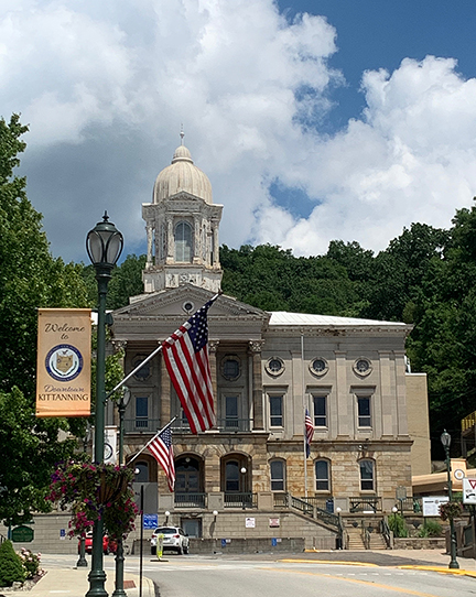
Next came Kittanning, a major urban outpost along the route, with a significant bit of architecture in the middle of town.

KittCH1104Web

Many sights along the trail were interesting, including Lock & Dam #8 (we saw #9 upriver on our next day’s ride). Here’s what the reader board said about the Lock & Dam system:

Following the American Revolution, the Allegheny River carried an extensive downriver trade including lumber, iron, oil, and passengers. Much of this river traffic ended after the building of the railroad along the river corridor in the 1860s. Yet the river nevertheless needed to be navigable. 

Lock & Dam #8 was constructed between 1928 and 1931 as part of the Allegheny River Navigation System. Several navigational locks on the river consist of single lock chambers and a “fixed crest” dam. This type of dam is a concrete wall across the river, creating a pool of water above the dam at lest 9 feet deep for navigation.

Prior to the construction of the locks and dams, some river depths could be less than 12 inches at certain times of the year, making the river non-navigable. Water that flows over these dams, however, cannot be regulated. Therefore the dams do not provide flood protection. Lock chambers are used to transition boats from and to the different levels of the water along the river.

Another sight is the remains of the Monticello Furnace (whose stack was demolished):

The Monticello Furnace was built by Robert E. Brown in 1859 to extract iron from iron ore. Originally the furnace was heated with charcoal but was later converted to a coke hot blast furnace. Iron ore and limestone were placed in the top of the furnace stack together with coke, which heated the furnace to produce pig iron. 

The furnace provided employment for as many as 200 people and produced 60,000 tons of pig iron, which supplied markets in Pittsburgh and Kittanning. The Allegheny Valley RR was extended to the Monticello Furnace in 1865 to deliver ore to the furnace. From 1866 to 1874, 20,000 tons of Lake Superior iron ore were mixed with local carbonate ore to produce a superior quality of pig iron. This was then used to make nails, steel tools, and other products of high quality. The furnace was in almost constant operation from its completion until it went out of blast in 1875. Near this site were 68 houses for workers and a PO, which operated in the company store. The Cowanshannock Train Station was established nearby. Later RR extension work covered the furnace’s stack, but you can still see the retaining wall near where the furnace stood. A large slag pile remains between the trail and the river.

We missed the Cowanshannock spur on the outbound run, but caught it on the return, and it was a fun short ride to the rocky section of the Cowashannock Creek where the water begins to tumble over large boulders, earning the name “Buttermilk Falls.”

CowCreek1103Web

Hungry and hot by the time we got back to Kittanning, we stopped at a place called Jim Fox’s Pizza and sat outside to eat a small pepperoni and inhale some sugary drinks and water.

Back at home base, our shower set-up worked great, although when the sun was on the Clam, it was terribly hot inside. Because we didn’t bother to crank the water heater for hot water, the cold water shower offset the discomfort and made for an excellent post-ride shower experience.

I put together some leftovers, added some of the remains of our earlier meal of pesto, and used that to top some pasta for dinner for a much-needed carb load.

Bike Stats: 32.64 miles; 2:50 ride time; 1:44 stopped time; 11.47 average MPH (84 feet of ascent—nice, flat trail).

On Saturday, July 25, we drove to Templeton Boat Launch to begin what turned out to be a much hotter ride, even though we started at about the same time of the day.

As we left Templeton we saw this monster chimney, which we dubbed “HellaChimney” attached to an electric plant of some sort. Our guess: it was a typical Appalachian coal-fired energy plant. But man. That chimney.

Chimney1106Web

The Guidebook recommended taking a different trail off the Armstrong to see two significant tunnels, for which riders must have headlamps to get through. 

RedbankTrMap1105Web

But first, we stopped at the Redbank Coaling Tower. A very impressive piece of construction:

During the era of steam-powered locomotives, trains traveling this RR corridor stopped at this coaling tower to fill their tenders with fuel coal. The PA RR Co. began construction here in 1928, and the coaling tower was placed into service in Feb. of 1930. It was used until 1957 when diesel engines replaced the last of the steam engines on this rail line.

Constructed of concrete poured into wooden forms made from locally-harvested timber, the lines from the wooden forms are still visible on the concrete. Coal from nearby mines was delivered to the tower in hopper cars and dropped into the pit (at the right of the photo below) then carried by conveyors (the slanted section) into the reservoir above the tracks (the round barrel). It was released into chutes, which directed the coal down into the tenders of the trains waiting beneath.

CoalingTwrTrail1111Web

Excerpt from the Guidebook: 

The Allegheny Valley RR developed the Redbank Valley corridor in the late 1800s to carry passengers, coal, and lumber to Pittsburgh and beyond. While passenger service along the line stopped in the 1940s, freight continued to be carried until the rails were removed in 2007.

Trail users can enjoy Redbank Creek’s waters along the corridor for 41 miles from the Allegheny River to Brookville. 

We enjoyed the 8 miles of the trail we rode, as we rose higher and higher above Redbank Creek’s waters—deep enough at the mouth for boaters to enjoy, but rippling and shallow by the time we turned around. 

Right about at the point where Redbank Creek’s boating depth was lost, was a nice little “covered bridge” across a significant feeder creek, and beside the remains of the trestle that used to carry the trains along Redbank’s corridor.

There’s even a perpendicular spur line that goes 9 miles up to Sligo, PA. That spur sports a 3% grade—a challenge not only for cyclists but also for trains as noted on the reader board below.

SligoReader1119Web

While the guidebook reports Redbank’s grade to be about 1%, we guessed it to be slightly more significant than that—maybe 2%. It was definitely a chug to get to the first (southernmost) tunnel, called Long Point Tunnel. 

We stopped for a snack on the north side of the tunnel, at a camping shelter dubbed “Ray’s Place” in honor of one of the trail’s dedicated volunteers.

Electing to return to Templeton instead of seeing the second (north-most) tunnel (Climax Tunnel) we linked back up to the Armstrong trail and rode without much incident (except catching sight of this extraordinary sculpture, below) back to Templeton Boat Ramp.

Sculpture1139Web

Bike Stats: 36.6 miles; 3 hours ride time; an hour stopped time; 12.46 average speed. 

ArmstrongTrMap1091Web

We celebrated our stay and rides with a ribeye steak dinner, accompanied by steamed-then-sauteed broccoli, and rice. An excellent end to an overall lovely stay with easy access to a great Rail-to-Trail conversion. Highly recommended.

Next stop: Raccoon Creek Lake State Park, PA—where Jack would have been staying (mostly) alone while I attended my job’s convention gathering in Pittsburgh, had it not been canceled due to Covid 19. So we will have 7 nights and many opportunities to cycle and cook. Our “new” Motto: We Travel to Cycle, and we Cycle to Eat.

Lake Erie State Park, NY

We saw a bear crossing the road en route to Lake Erie SP, in the middle of Galeton, PA, July 17. Amazing. While it was a very pleasant drive along back roads most of the way, the bear was definitely a highlight.

Our site, #29 is not on the water, and there is little or no separation between sites, but we had a corner lot with a beautiful young oak tree that Roomba just fit under. On the first day, we realized as the sun set into the western Lake waters, how incredibly hot for too many hours Roomba was exposed to. So we ran the AC quite a lot and had to manage the windows etc. for weather and noise.

Site29Corner0983Web

It was, however, a very quiet campground. Even with the large rigs and boats on trailers parked everywhere for the weekend, it was very sedate, despite the fact that many children were riding bikes and other toys around and around.

ParkMap1087Web

The bathhouse was only okay. There were **supposed to be** four private toilet stalls and 2 showers (for each gender, men’s on one side and women’s on the other) for the majority of the campground (exception being the cabins, which are quite primitive but have a separate bathhouse area that any nearby camping sites would have access to). When we arrived, one women’s toilet was marked “out of order” and by the time we left another was officially out of order, and a third was locked from the inside (likely by kids). So we “wimmins” were down to one toilet and 2 showers. The stalls were elderly and I’d bet VERY difficult to clean, so we were extra careful about carrying disinfecting wipes with us to the facilities here.

At the end of the road, we faced (staring also at the campers across the road from us who were backed against a narrow but thickly-grown wood) was a mowed access point to the “beach.” Personally, I’d call it a “shingle” as there’s no sand in sight and not much in the way of space to spread out blankets, chairs, picnics, or whatever.

Shingle0959Web

That evening we went out to one part of the frisbee golf “lawn” above that shingle and watched the sunset from atop a picnic table. It was pretty cool—in the pix below you’ll see some peeps who swam out to a—not sure what it was, but suppose it was a raised bit of shale or rocks that they were walking on. We never took a swim, but it appeared the water was quite deep very suddenly off the shingle, and everyone either kayaked or swam out to this raised place to stand.

After the sunset, we stayed long enough to see a 3-star International Space Station (ISS) pass around 9:15. But then these monster mosquitoes chased us back up the hill and to bed. Our intention was to see Neowise Comet 2020, but the mosquitoes won that round.

Saturday, July 18 (Happy Birthday, Andy M!!) We went into Fredonia for groceries and drove around a bit, checking out the environs. Mostly looks like old neighborhoods, many gone to seed, but still some majestic old homes. There’s really no place to ride around here, try as we did to find bicycle trails with limited vehicle traffic. Too bad there’s not a “lakeside trail” of some sort, but I’m sure that real estate is quite upscale.

There is a “NY State Seaway Trail” but it’s all about driving.

SeawayTrail1005Web

I worked on the Green Lakes and Leonard Harrison blog posts and the attendant photo sizing from my office in the Clam. It was quite nice working from there, with a modicum of privacy, fans going to stir the air, and room to spread all my maps and papers around. We’d set the Clam over top of the picnic table, and that served as my desk (but I had to get a pillow under my butt after a short while—those benches are HARD).

It was another beautiful night for sunsets, and we determined to stick out long enough to see Neowise, prepared with bug spray, long-sleeved shirts, and long pants (it was really too hot for all that mess). I remembered to bring my binoculars and we sipped our adult beverages.

The sunset was not quite as impressive on this night, even though there were more clouds. We feared we’d not be able to see the comet with the clouds, but they moved along pretty quickly. I caught a kayak headed to the strand in the sunset and thought that was worth sharing.

It took a very long time for the sun’s glow to dissipate enough for us to see Neowise with the binos, but we managed at last. We’d gotten the skinny on where in the night sky to seek the comet (just horizon-ward from the Big Dipper, which was actually in the “paw” of Ursa Major). 

It was very cool. I tried to take a pic through the bino lens, but that wasn’t going to happen. It never really got dark enough for a photo or to see it with our naked eyes—both of us were certain we could see some of the tail without the binos, but it might have been our imaginations.

We did see another ISS pass, and other folks who came up behind us asked about the comet and we said, yes, we had binoculars, and we’d seen it. When we suggested they’d just missed the ISS, they said, “No, we saw it!” Then the guy said, “What a great night for nerds, right?” We all laughed.

The mosquitoes were vicious again, and even with spray and extra clothes, we were eaten—and these suckers leave behind an anti-coagulant to which I seem to be particularly allergic. So at about 11, with the horizon still too bright to see the comet without binos, we called it a night.

On Sunday, July 19 & Monday, July 20 (Happy Birthday, Chip C!!), many of the neighbors left, so we got our “elbow room” back and it was truly glorious. This is a very nice campground, and our site was really the best on offer, in our opinion—protected from the winds off the lake (important detail later in the day).

The breezes came up and the clouds portended some stormy weather. But before that came, we took a ride around the CG and only made about 4 miles on all the paved (and some unpaved) roads/trails about. Not much to this SP, frankly. And some reader boards explained what we suspected: that the SP is eroding into the Lake. They have an old “recreation” building off the “beach” that might have been closed due to Covid, but looked as if it’d been decommissioned long before the pandemic. It’s right on the edge of the bluffs, so it has likely been condemned due to erosion.

We rode our bikes along some “hiking trails” several of which had been converted to frisbee golf course “fairways.” I think I found the source of the mosquitoes from Hell: a swampy, marshy area that had little to recommend it except lots of swamp wildlife and these enormous, red-bellied mosquitoes. We also learned about the erosion of the park, creating the “bluffs” of Lake Erie.

Before the rains came, I managed to make us another “dump cake” in the Dutch oven with fresh blueberries and spice cake mix. It was pretty good—better than using pie filling (too sweet). Dinner was a split Cornish hen with dry rub spices grilled to perfection. Jack also grilled some squash for us, and with dessert, it was a memorable meal. Then the rains hit, with a significant blow—a nearby tree lost a branch.

StormChop1014Web

The storm Sunday made for some very pretty sunset photos, some of which we enjoyed from inside the trailer:

We even got an interior reflection pic—this is the eastern set of windows reflecting the sunset as it happened, through the western set of windows:

03SunsetInterior1052Web

On the Monday, with so few people at the campground and cooler temps after the storm, we did some maintenance work, cleaning Roomba. Jack washed exterior windows, and I worked on the blog and helped with window work later.

We are doing pulse oximeter and temperature readings on Mondays, and today’s were all again within our norms. The air was so fresh we actually turned off the AC for the night and ate outside for a change: grilled scallops wrapped in bacon, grilled sweet corn, and rice. Yum.

Scallops1064Web

On Tuesday, July 21 we headed pretty early into Dunkirk to visit the public library there. It’s an old structure, and their very well-equipped computer room had been reduced to 4 functional computers/stations, 6 feet apart from one another. While I had my own computer, we still had to take up a station and stay apart from one another. Jack “airdropped” me some photos I wanted to use, and I put everything together into one 2-part and one 1-part blog post upload. The “library police” (with apologies to all my librarian friends) allowed us only an hour to take up a station, so I worked quickly and may have missed some typos in the process. If so, extra apologies.

We lazed and lounged back at camp, beginning to break down stuff and get ready for departure the next day.

Got out the pizza stone (custom sized to our grill) and put together a pair of pizzas using pre-made crusts and man, were they good!

Pizza1070Web

Another memorable sunset, with classic Alto reflection pix, the best of which is this one:

ReflectionSunset1069Web

Next stop is an unserviced Army Corps of Engineers property in Pennsylvania: Crooked Creek Lake Recreation area. 

Leonard Harrison State Park, PA

On Monday, July 13, we arrived at Leonard Harrison State Park in Pennsylvania. Jack has some family near here and on previous visits, we’ve ridden the section of the Pine Creek Rail Trail from its southern terminus in Jersey Shore to the parking area near Waterville, about14 miles one-way. Our goal for this visit was to cover the remainder of the total 64 miles of the Pine Creek Trail.

StateParkMap0920Web

Our site, #24 was electric only, and the loop had a beautiful bathhouse serving a total of about 28 sites. The camp was quiet and tidy but we never saw a host, no office personnel, no on-site sales of ice or firewood, and it was a self-check-in arrangement. Once or twice, we saw a ranger matching license plates with registration info.

Site24-0981Web

En route, we’d shopped at a very clean and tidy Weis grocery store in Wellsboro, the town nearest the park, and recommend it if you ever stay here. Another feature near the park is what they call Pennsylvania’s Grand Canyon—part of the gorge through which Pine Creek (more like a river) threads its way south.

Once we set up, and not knowing exactly how far a jaunt the actual overlook of the Gorge was (it is, in fact, well within hiking distance up the road) we drove to the parking area and wandered around the overlook area (most conveniences closed, but the trails were still open and rather busy).

It is/was quite stunning. The trails and structures were all made during the 1930s as part of the Civilian Conservation Corps work, including this “incinerator” which we guessed might have been used back in the 30s for waste management during construction and while the CCC personnel were living and working in the area.


While it’s nice to discover that the businessman named Leonard Harrison donated this land to the state in 1922, it is difficult to learn that he only did that after years and years of exploiting the harvestable resources of the area (in his case, timber) and then leaving the land naked and eroded, the Pine Creek silted up, and the business “value” of the property near nil.

In fact, the entire history of Pine Creek is one of exploitation, greed, and recovery after abuse. It is a sad history, but one we must face, because much of the “new world” was settled specifically for businesses and business families to reap its exportable resources—exploitation is the watchword for America’s (and Canada’s) 19th and early 20th centuries.

Here’s a quick bit of history about Pennsylvania’s “Grand Canyon” and other natural treasures of the Americas:

The region’s massive old-growth pines, hemlocks, and hardwoods were harvested and floated or railroaded to distant shipbuilders and other construction companies to keep up with the demands of the growing nation. Natural resources were mined, sawn, hunted, fished, quarried, and otherwise extracted to fuel the country’s new growth, without any thought to future generations—most believed the resources could always easily replenish themselves.

Land purchases by state and federal government agencies and laws passed locally and federally sought to heal and protect the ecosystems nearly destroyed by prior abuses.

    • Pre-1650: Before European settlement of the Americas, the forests grew and changed with the natural rhythms of the earth. The first Americans arrived in eastern North America about 12,000 years ago and lived in relative harmony with nature.
    • 1750: Attracted by the prospect of a better life in the “new world,” European settlers arrived in increasing numbers and began to exploit the continent’s vast resources.
    • 1880: The Industrial Revolution hit full stride. The US expansion reached all the way to the Pacific. The wood, coal, and other natural (extractive) resources found in the wilds of Pennsylvania helped build a new nation.
    • 1910: Except for a few respite acres, the forests of Pennsylvania were completely stripped of trees. The streams were [polluted with mine acid and silt, and the wildlife had been market hunted to near extinction. It was the worst of times for our natural resources.
    • 1920s-1930s: The Chestnut Blight felled the mightiest of the eastern forest members.
    • 1930: Visionary Pennsylvanians led the way to begin to repair the damage to the ecosystems. Conservation organizations had been established, and the Civilian Conservation Corps (CCC) replanted millions of trees to regrow the forests.
    • 1950: The abundant habitat, created as our new forests began to grow, caused deer numbers to reach an all-time high. In the prosperous post-war era, PA’s state park system grew to over 100 parks, and citizens had more free time, many of whom spent that time in the outdoors.
    • 2008 (when this readerboard was created): PA’s state forests and parks today number 2.1+ million acres. These systems remain as a gift from our predecessors, who entrusted this legacy to us to conserve and protect for future generations.

But back to the Grand Canyon. We took a lovely hike along Overlook Trail to Otter View (where no otters were viewed) and took many photos from the various heights, knowing that in the next days, we’d be down in that gorge, following the course of the waterway that carved it over many millennia.

LeeOtterView0887Web

Jack had read (and we had hoped) that the trail from the park down into the gorge might be navigable by bikes. It was called Turkey Path, and an update Jack had noted before we’d arrived reported that there had been some erosion and that parts of the trail were closed. But we found the trailhead blocked, and having walked the Overlook trail, there would have been no possible way for us to cycle down any of the hiking trails along the steep gorge “rims.”

TurkeyPathClosed0914Web

Additional notable aspects of this camping stop were the cool daytime temperatures and the downright chilly nighttime temps—we awoke to several mornings in the mid-50s. Excellent for campfires and wee drams by the fire.

On Tues., July 14, we rode Pine Creek Trail from its northern terminus (near Stokesdale, from the Butler Road access parking area) to the historic area still known as Tiadaghton Village, which was about 16.5 miles one-way, for a tad more than a 32-mile round trip. 

TiadaghonReader0933Web

When we finished our ride, we stopped to get sandwiches at a trailside farmer’s market and deli, and ate in the car. They served enormous 6-inch subs (excellent bread) piled high with whatever deli meat you asked for. Jack got an “Italian” and I was excited to see they offered one of my favorite sandwich meats: Lebanon bologna. I think that sandwich gave me my year’s allotment of Lebanon bologna.

After our ride, we drove into Mansfield to find propane for the grill, a beer store, and a library so I could upload the Waterhouse CG blog post. It was a small, quiet library with robust wifi, and I sat in the downstairs “children’s section” all alone and did my thing pretty easily.

Because of that lunch, we decided to postpone our intended pork loin dinner in favor of something lighter, finishing off the day with a wee dram beside the Solo stove fire—in fact, we stayed up unusually late for us—and as we walked back from the bathhouse, I randomly looked up at the beautiful night sky and saw the ISS passing high and fast, and for a very long time, through the darkness. Even though Jack has an ISS spotter app, there is zero cell service and we didn’t know it was heading by that night. It’s almost better to see it by chance than to know it’s coming (although we regularly watch for it if the app tells us it will be coming past before our bedtime).

Bike stats: 32.87 miles; 2:30 ride time;32 minutes stopped time;13.22 average speed.

Wed., July 15 we rode the trail from Slate Run Access (about MP35) back to Tiadaghton Village, stopped for a Kind bar in the picnic area, and used the comfort station. We didn’t see many decent roads to get us to access/parking areas to start near Tiadaghton, so we decided the easiest way to get the trail covered was to go from our Day 2 endpoint to Tiadaghton and back. This time, the home (return) run was downhill, but we still did not manage to match our average speed from the day before (see stats above and below).

As we rode along, crossing an old rail trestle near the village of Blackwell, we saw a large dark bird sitting in a snag near the bridge, assuming it was a vulture. When it took off, however, the yellow of its cere and some of its beak, and yellow legs, not to mention the feathers all over its head (thus not a vulture) and its motley brown/white wing feathers, indicated that it was an immature or sub-adult golden eagle.

Since that sighting, we’ve discovered there are tons and tons of golden eagle sightings in that area, and Little Pine State Park has at least one nesting pair of goldens. On the web, the PA game commission has noted many golden sightings along Pine Creek’s gorge.

So that was cool. I never saw it again, once it took off, and (of course) didn’t get a photo because the trestle sides were too high for me to see over.  **sigh**

At the end of the ride, and across the bridge from our Slate Run parking area was the Mason Hotel and Restaurant. We saw umbrellas on their deck off the creek and went over for a sandwich. Although it was a very pricey meal, we had excellent fish sandwiches on very good kaiser rolls and beautiful French fries. Again, it was so much that I had to take part of my sandwich home and ended up reheating the fish and replacing the bread to enjoy quite a good fish sandwich again, a few days later.

It was a long drive over narrow backroads to get back to camp, and after showers (and I lubed my chain covered in dust) we put together the intended dinner from the day before: pork loin, grilled fresh sweet corn, and boiled baby potatoes. Yum.

Bike stats: 38 miles; 3 hours ride time; 40 minutes stopped time; 12.77 average speed.

Day three of our Pine Creek Rail Trail effort was Thursday, July 16. Notable on this day was seeing a Cooper’s hawk calmly sitting atop a pine snag watching traffic, and several hairy woodpeckers pounding on pine trees along the way.

We also saw 6-7 deer on or beside the trail, and one crossing the creek.

DeerCrossing0955Web

For this segment, we started near Waterville and rode to our prior day’s endpoint (Slate Run) and returned downhill to finish. One strange place we passed through was a village named “Cammal.” When we went by the readerboard about the place, a picture of a camel caught my eye.

CammalReader0951Web

The highlight of the day happened on the return—actually, it was more a severe fright at the time, although definitely a rare sighting. Backstory: all along the entirety of the Pine Creek Trail are reader boards about timber rattlesnakes, and how they deserve to live in their native habitat, etc. Yeah, yeah, yeah. Jack passed the multiple boards with the same info and pix off to letting hikers know about the possibility of encountering a rattler along the hiking trails. We honestly didn’t think a timber rattler might be found on the busy, wide-open Pine Creek Rail Trail.

RattlerReader0893Web

Well, I was ahead of Jack on the return to the car (we hoped to match our first-day 13 average MPH speed and were cranking it on the downhill return) and saw what I thought was a large branch across 2/3rds of the (very wide) trail. It even had yellow and what I thought might be green on it, so I was pretty sure it was just a long branch. 

When I got closer, however, I saw the rattles on one end, large yellow diamonds in the middle, and the tiny, pinhead (in comparison with its middle) on the other end. I quickly noted that the widest part of the trail through which to steer my bike without hitting it was at the head end. Uh-oh.

I shouted to Jack that it was a snake and that it was a rattler, after I swiftly passed the head end without incident, and yelled at him to watch his ankles. This thing was huge—probably 4 feet stretched out, and about 2-3 inches in diameter at its thickest part. Evidently, after I passed, it had drawn up some, because Jack didn’t guesstimate it was as long as I’d estimated. And of course, I was so “rattled” and also did NOT want to disturb a venomous predator that huge, I did not go back and get a photo. **sigh again**

But it was scary and beautiful, with its bright yellow diamonds and impressive girth. It must have eaten something rather large recently. Or—I don’t know anything about rattlers—maybe they’re all that thick in the middle.

ANYWAY, those are the highlights of our stay at Leonard Harrison State Park in PA. Very nice camping, excellent cycling, and great for seeing beautiful sights and critters. We are so glad the state of PA has reclaimed, healed, and preserved this treasure for enthusiasts like me. Although, it is good to take note that it’s not easy to get from any “Point A” to any “Point B” along the length of the Pine Creek Rail Trail, as the roads are tiny and confusing and there’s this enormous deep gorge in the middle of everything.

Bike stats: 30 miles; 2:25 ride time; 35 minutes stopped time; 12.45 average speed.

Next up: Lake Erie State Park, New York

Green Lakes State Park, NY—Part 2

This post has been broken into parts to make the upload easier. If you missed Part 1, please click HERE and you can catch up before reading Part 2 of our Green Lakes SP adventure.

We took our second full day at Green Lakes (Saturday, July 11) as a recovery day, doing not much of anything except resting and drinking liquids. At one point, we got curious about the actual Green Lakes, and lit into the forest for a hike, intending to be on a trail that, on the map, indicated it would be no longer than about a mile around Round Lake.

The trail maps were extremely misleading, or the user-created “trails” in the woods are so numerous and permanent that newcomers (like us) believe we are on a mapped trail when in reality, we’re completely confused. Our under-a-mile walk, which was totally lovely, btw, turned into nearly 3 miles.

In any case, we got into the woods behind our site and trekked along high along a ridge above Round Lake. It was a nice walk, even though we were not near the actual lakeside until well into the hike when we found the mapped trail.

Hiking0895Web

MappedTrail0905Web

When at last we descended from the ridge to the waterside, both lakes were awesome. That strange emerald green color of the water distracted from its amazing purity and clarity, which could be seen at the water’s edge.

GreenWaterThruTrees0892Web

GreenLakes0904Web

There were many un-masked people along the main, mapped trails, so we skedaddled back to the ridge and our campsite, and ran into this “Old Man of the Woods” on our way through part of the Old Growth Forest and back up to our high ridge.

OldManOfTheForest0900Web

We had a good, satisfying dinner of grilled kielbasa & onion slabs, and fried potatoes. Several rain showers during the dinner hour ran folks indoors and under cover, but the showers stopped for a few hours. And that night there came an enormous thunderstorm, that dumped buckets of rain on all the partiers and tents—some of which collapsed under the pooled weight of water. There was quite a lot of nighttime activity with folks shining car lights and flashlights on wrecked picnicking and camping structures. It was quite a night.

On our second riding day (Sunday, July 12) we awoke to numerous drenched people forlornly cleaning up their soggy equipment and sites after the storm. It’s difficult to be humble, and I have to admit, we were somewhat self-satisfied with the security of our Alto.

As most of our camping neighbors left town, we drove to a deserted parking lot adjacent to a decrepit “living museum” area called “Erie Canal Village” west of Rome. There was a lone killdeer in the high grasses near the parking area trying to lead us away from its nest, and two hearty tourists determined to see what was to be seen in the “village.” 

Which was not much other than this old canal boat, disintegrating in the canal below a pedestrian bridge that was closed to the public.

OldCanalboat0907Web

It was a cooler day, after the storm, which was a blessing. But it was nevertheless in the 80s. 

We had elected not to pack our lunch as we knew there would be plenty of urban riding through Rome and in Utica, and thus places to grab a sandwich along the way. Rome routed us through some nice backroad neighborhoods, and there was only one section that was unpleasant due to traffic. On the return through that part, it began raining on us, and although it never got terribly hard (and there was no lightning) we got pretty wet on our hands and feet.

BridgeMuralCanalway0886Web

Anyway, we rode through Utica to the endpoint of the constructed trail, checking out one lock of the system along the canal: Lock #20. There was a lovely park where we could get into the shade and we snacked on a couple of Kind bars for energy.

CanalLock20-0911Web

After turning around and riding back from the east side of Utica to the west side, we stopped at a Citgo fuel station in Oriskany, where a Cliff’s Pizza and Subs was housed, and we had sandwiches built to order (like Subway, but with far better bread and toppings) and ate lunch outside at their shaded picnic tables. We ended up carrying half of one sandwich home and ate it with a salad for dinner.

Somewhere along the way, we saw this spillway from the canal to an adjacent creek and I thought it looked cool, so I stopped for a pic.

Canal2CreekSpillway0883Web

The rain had stopped by the time we got back to the car, and our killdeer was probably sheltering on its nest. We were glad to have New York’s Erie Canalway Trail to cross off our “done” list, despite having missed a small number of miles of its entire length. But it was a good couple of days’ riding and we were satisfied with the effort and the exercise.

Bike stats: 35.62 miles; 3 hours ride time; 1:40 stopped time; 11.56 average speed.

History

The Canalway Trail System (incomplete)

The imagined/planned Canalway Trail System will offer hundreds of miles of scenic trails and numerous parks for walking bicycling, cross-country skiing and other recreational activities It parallels the New York State Canal System, comprised of four historic waterways: the Erie, the Champlain, the Oswego, and the Cayuga-Seneca Canals. The Canal System spans 524 miles, linking the Hudson River with Lake Champlain, Lake Ontario, the Finger Lakes, the Niagra River, and Lake Erie. When completed, it will be one of the most extensive trail networks in the country.

CanalwayMap0878Web

The Old Erie Canal State Historic Park is a 36-mile trail following the canal’s towpath from DeWitt (just east of Syracuse) to Rome (west of Utica). [We cycled the entire Old Erie Canal part of the Canalway Trail from the Green Lakes SP access point (~5 miles east of DeWitt/Syracuse) through Utica where the trail ends. It took 2 cycling days, one of which included driving to an obscure access point where we saw an ancient canal boat (shown above in post) in a decrepit “living museum” called the Erie Canal Village, and some significant (unpleasant) urban cycling.] This scenic trail passes through a variety of natural and cultural landscapes including open farmland, dense woods, and old canal communities. Originally part of the Enlarged Erie Canal that ran from Albany to Buffalo, this section now serves as a feeder for the New York State Barge Canal.

CanalwayMapMarcy0912Web

The Enlarged Erie Canal

Workers began the construction of the original Erie Canal in 1817 on the flat Oneida Lake Plain between Syracuse and Rome. This section of the canal was known as the “Long Level” and did not require the construction of locks. Completed in 1825, the Eire Canal (then called “Clinton’s Ditch”) was an immediate commercial success, converting the Syracuse area from a swamp into a thriving commercial center. The initial canal stretched 363 miles, averaged 40 feet wide at the surface, and maintained a depth of 4 ft. It could carry 75-ton boats. 

Rome Summit Level

The Old Erie Canal State Historic Park encompasses all 36 miles of the Rome Summit Level, running from DeWitt to Rome. The park not only preserves this section of the historic canal but also serves an important purpose today, as this stretch of the old canal feeds today’s NY State Barge Canal System. The two canals join in New London, between Oneida Lake and Rome.

Increasing traffic soon made it necessary to enlarge and re-route parts of the canal. The “Enlarged Erie Canal” construction was begun in 1836 and finished in 1862 and was deeper (7 ft.), wider (70 ft.), and straighter than the original. In some places, the Enlarged Canal was built directly on top of the original. In other places, a new course was laid to eliminate unnecessary twists and turns. The Enlarged Erie could handle boats carrying 240 tons of cargo and decreased travel time.

The NY State Barge Canal opened in 1918, and the “Enlarged Canal” was abandoned. Today’s canal is a combination of artificial waterways and existing lakes and rivers. While it uses much of the original canal, it takes a norther route through Oneida Lake, bypassing the Old Erie Canal State Park. It is 12 feet deep and varies from 75 to 120 feet wide in the artificial channels.

Chittenango Landing—About the Boats

ChittLandingCanalBoatMuseum0877Web

In its heyday, boats traversing the canal transported both a diversity of people and goods. Many different boat styles traveled the canal and each was designed for specific cargo.

Packet Boats carried people. Each passenger was assigned a cramped sleeping quarter. Men’s and women’s quarters were often separated by a curtain. The men’s quarters doubled as the dining room and saloon during the day. Boat owners tried to pack as many people into the boat as possible, allowing them to charge less than a stagecoach.

Freighters transported a variety of raw materials and manufactured goods along the canal. A fully covered boat called a “bullhead” protected cargo that needed to stay dry (flour and grain). The uncovered deck “skows” transported goods like lumber and coal, which could be moved without protection. Raw-material cargo often traveled east towards Albany while manufactured goods typically traveled westward.

Line boats worked much like bus or rail lines today. Line companies stationed teams of mules in barns along the canal. Working mules simply switched with rested ones at the designated stops. The cabin space that would have been used for mules became available to human passengers who could not afford packet boat fare. Carrying both cargo and people was very profitable, and in the middle of the nineteenth century, line boats made up 50% of the canal’s vessels.

Feeding the canal

ChittFeeder0875LWeb

In the picture above is the Chittenango Canal, which supplied water directly to the Erie Canal from Chittenango Creek.

The Chittenango Canal Company built it in 1817. It collected tolls and maintained the more than mile-long canal, which ran to the southern end of modern-day Chittenango. The canal contained four locks, each raising the water level 6 feet. Sawmills, stores, and other businesses thrived along the canal until about 1852. NY State bought it in 1860 and portions were eventually filled in.

Where does the water come from?

Cazenovia Lake and Tuscarora Lake are reservoirs that feed Chittenango Creek. Similarly, Jamesville Reservoir feeds Butternut Creek, and the DeRuyter Reservoir feeds Limestone Creek. Water from each of these creeks is then diverted into their respective feeders: Chittenango Creek into the Chittenango Canal, Butternut Creek into the Orville Feeder, and Limestone Creek into the Fayetteville Feeder.

If you clicked here from the middle of Part 1, this LINK will take you back there.

Otherwise, stay tuned for the travelogue of our next stop: Leonard Harrison State Park in Pennsylvania, and our rides along Pine Creek Trail.